Contrails - Research, comments and links
Contrails and Aviation-induced Cirrus Clouds
Various
(still to be edited and distributed over the pages)
The Atmospheric Sciences group at Oregon State University studies the dynamics, physics and chemistry of atmospheric phenomena and processes, including the interactions of the atmosphere with soil physics, hydrology and oceanic circulation. Its graduate program provides an understanding of atmospheric processes on local, regional and global scales using observations, analytical and numerical methods. Graduate student research focuses on one of these areas of faculty expertise: turbulence and convection, atmospheric radiation and remote sensing, aerosol and cloud physics and chemistry, planetary atmospheres, air-sea interactions, climate, and statistical meteorology.
Faculty and graduate students in Atmospheric Sciences are presently working on approximately 20 research grants and contracts. In addition, faculty members conduct joint research with the National Center for Atmospheric Research, and NASA Ames Research Center, the Center for Clouds, Chemistry and Climate at the Scripps Institution of Oceanography, NASA Langley Research Center, as well as with research centers in England, the Netherlands, Denmark, Sweden, and France.
Atmospheric Chemistry: A program of atmospheric chemistry research is conducted by Richard Vong and Cynthia Twohy. This work includes measurement of the chemical composition of atmospheric aerosol particles, cloud droplets and precipitation. Vong's group has developed eddy flux measurement techniques for cloud droplets and is currently extending this work for measuring aerosol eddy fluxes. Twohy's group conducts airborne research related to chemical and microphysical properties of clouds and their nuclei.
Jim Coakley, a COAS professor studies the role of clouds in the Earth's energy budget and climate. One of the more publicized issues in atmospheric science is the greenhouse effect. Coakley is interested in the role clouds play in the climate system. Clouds could potentially have a large impact on the response of the climate to the buildup of pollutants in the atmosphere. For example, as the amount of greenhouse gases increase in the atmosphere, less heat escapes from the earth; the trapped heat causes global warming. If the warming leads to a buildup of low-level clouds, then more sunlight will be reflected and the warming will not be significant. If the warming leads to a decrease in low-level clouds, then less sunlight will be reflected and the warming will be amplified."If we don't know how clouds are going to change, we are at a loss to predict what is going to happen as the greenhouse gasses build up in the atmosphere."Statistical and quantitative analysis is conducted on satellite and aircraft data to identify how clouds behave. New insights of cloud behavior are incorporated into models of how clouds work. These models are tested and compared with cloud observations before being used in models of global climate.
Jim Coakley
The model is then tested and if it bears out to be statistically significant, then the model is used in models of global climate.
Projects
- Characterization of clouds and the anisotropy of radiation fields (NASA-CERES)
- Limits to cloud susceptibility (NASA-GACP)
As a consortium of universities dedicated to education
and research to
enrich our understanding of the earth system, UCAR manages the National
Center for Atmospheric Research (NCAR) and the UCAR Office of Programs
(UOP).
https://www.ucar.edu/ucar/weather.html
Subsonic Aircraft Contrail and Cloud Effects Special Study (SUCCESS) MODIS Airborne Simulator (MAS) Level-1B Data Products
The objective of the Subsonic Aircraft Contrail and Cloud Effects Special Study (SUCCESS) was to use scientifically instrumented aircraft and ground based measurements to investigate the effects of subsonic aircraft on contrails, cirrus clouds and atmospheric chemistry. The data was collected for the MODIS Airborne Simulator (MAS) project. This data will help define, develope, and test algorithms for the Moderate Resolution Imaging Spectroradiometer (MODIS) sensor which is a key sensor of NASA's Earth Observing System (EOS). The SUCCESS data are available from the NASA Goddard Space Flight Center Distributive Active Archive Center (GSFC/DAAC). The data cover the Central United States. Browse imagery of the data may be viewed from the MODIS Homepage at: https://ltpwww.gsfc.nasa.gov/MAS/successhome.html To order HDF formatted MAS data, link to the GSFC/DAAC homepage at: https://daac.gsfc.nasa.gov/CAMPAIGN_DOCS/MAS/mas_bin.html. [Summary adapted from the GSFC/DAAC homepage]
U.S. Air Force Upper Air/Contrails Climatology (UACLIMO)
Upper Air/Contrails Climatology (UACLIMO, Version 2.0) is an interactive upper air climatology PC-based program. UACLIMO produces climatological information for several flight legs of a flight route or information for a single point on the globe. The data was derived from the European Center for Medium Range Weather Forecast (ECMWF) upper air database at a resolution of 150 nautical miles (nm) between data points. The UACLIMO software displays vertical profiles from the surface to 100 mb for the following variables; pressure, height, temperature, D-value, wind speed, wind direction, and wind factor. The program interpolates data values for the aircraft's vertical position, then place the aircraft data relative to the mandatory pressure levels. The dataset also includes climatological contrail probabilities. The software produces graphical displays of the percent probability of contrail formation. The probabilities are dependent upon flight level and engine type. The user can specify 4 different engine types. The contrail probabilities are calculated by comparing the monthly mean temperatures and standard deviations (from the ECMWF database) to "critical temperatures" for contrail formation. The critical temperatures were calculated through discriminant analysis techniques developed from a large database of pilot reports (PIREPS). The software was designed for an IBM-PC or compatible and requires a 286 or better processor, CGA or EGA graphics, MS-DOS 3.2 or higher, 640K bytes main memory, Epson-compatible dot matrix or laserjet II printer for hard copy graphs, 1.1M bytes hard-disk space. The data require an additional 25M bytes hard-disk space.
Contrails are clouds formed around the small particles (aerosols) which are in aircraft exhaust. When these persist after the passage of the plane they are of great interest to researchers. Under the right conditions, clouds initiated by passing aircraft can spread with time to cover the whole sky. See an article by CERES researcher Dr. Pat Minnis.
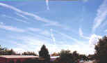
Contrails are human-induced clouds that only form at very high altitudes (usually above 8 km) where the air is extremely cold (less than -40�C). If the air is very dry, they do not form behind the plane. If the air is somewhat moist, a contrail will form immediately behind the aircraft and make a bright white line that lasts for a short while. Persistent contrails form immediately behind the airplane in very moist air. These long-lived contrails will usually grow wider and fuzzier as time passes. Sometimes they will actually take on the characteristics of a natural cirrus cloud and no longer look like contrails after only a half hour or so. Persistent contrails can exist long after the airplane that made them has left the area. They can last for a few minutes or longer than a day. However, because they form at high altitudes where the winds are usually very strong, they will move away from the area where they were born. Often, when we look up into the sky, we will see old persistent contrails that formed far away but moved overhead because of the wind. An example of several very persistent contrails is shown in the S'COOL cloud chart. Persistent contrails are those most likely to affect climate.
https://asd-www.larc.nasa.gov/SCOOL/contrails.html
Contrail Formation Forecast
The page provides access to both real time and archived contrail formation forecasts from Rapid Update Cycle (RUC) model data.
The RUC model data are representations of the complete 3-dimensional structure of wind, temperature, and humidity over the USA at a resolution of 25 mb and 40 km. The horizontal resolution has been degraded to 1� latitude x 1� longitude to facilitate the computations. Because they are based on a sparse number of actual in situ (balloon sonde) data taken every 12 hours and satellite measurements, the RUC data are not a perfect representation of the various meteorological parameters, especially water vapor. The model humidity at upper levels of the atmosphere is often too low, reflecting the current biases known to exist in our measurement system. Persistent contrails require a relative humidity with respect to ice (RHI) that exceeds 100%. We know that contrails are sometimes observed in areas where estimates of the RHI are less than 100%. The existence of contrails in those locations highlights the "dry-bias" in the humidity fields.
Because the input data do not perfectly characterize the meteorological conditions, the diagnoses of persistent contrail conditions are only estimates and will not detect all of the areas where persistent contrails will form and may also add areas of formation that do not exist. All estimates of persistent contrail formation conditions are based on a modified Appleman curve using three different engine propulsion efficiencies. To give some idea of where contrails may form, but are not diagnosed, we have included information about RHI for values above 70% for single-level plots.
Two forms of results are presented.
- Favorable contrail conditions, for a range of pressure levels between 125 and 400 mb, are represented as concentric circles - color coded with reducing diameter for each level. These results can be displayed for engine efficiencies of 0.2, 0.3, and 0.4.
- Favorable contrail conditions at each level, represented by 'X', along with relative humidity w.r.t ice (RHI). These results are only available for engine efficiencies of 0.3.
The contrail forecast software was developed by Dr. David Duda of Hampton University with Patrick Minnis (NASA), with support from the NASA Office of Earth Science Pathfinder Program. The near-real time display was constructed by Rabindra Palikonda (AS&M, Inc.). For more information contact Dr. Duda ( d.p.duda@larc.nasa.gov ) or Dr. Minnis (p.minnis@larc.nasa.gov).
The relative humidity data from the RUC 40km model are suspect since 18 April, 2002. Therefore, all contrail forecasts since April 18, 2002 are suspect.To obtain a better estimate of potential contrail formation, examine the 'Individual level (mb)' results. Select a pressure value between 200 and 250 mb for the best estimate. Relative humidity values above 80% are good indicators of contrails in the new RUC data. You can use any pressure level , but the large values may be too warm for contrail formation.
Jets Create Serious Cirrus Clouds
Add to the list of rogues a possible new humanmade factor behind climate
change: ![]()
![]()
At high altitudes, particles in jet exhaust
become seeds for ice crystals that make up contrails. Ice crystals reflect
sunlight during the day, possibly cooling the ground below. They may also trap
heat after the sun goes down and make the nights warmer. In the 1960s,
scientists proposed that fleets of planes could spawn enough contrails to tweak
the climate in industrialized regions. Recent satellite studies over Europe
showed that contrails cover about 1% of the sky--seemingly not an important
amount. However, those satellites watched only the most obvious contrails: long,
narrow streaks, many of which fade quickly. The new research reveals that other
contrails can elude detection by mutating into strikingly large, cirruslike
clouds.
NASA researchers used geostationary satellites to
continuously track three sets of contrails over California and the southern
United States in spring 1996. The contrails, floating at altitudes of about 10
kilometers, lasted between 7 and 17 hours and expanded to enormous sizes by
catalyzing the growth of a larger cloud with more ice. One cloud reached 35,000
square kilometers--the size of Indiana. At such extents, no satellite or
ground-based instrument would recognize the clouds as having arisen from
contrails, says atmospheric scientist Patrick Minnis of NASA's Langley Research
Center in Hampton, Virginia. If more high clouds that look like natural cirrus
are old contrails in disguise, Minnis says, "that could have a strong
regional effect on climate." Indeed, other studies point to an increase in
cirrus clouds during the last 30 years, possibly due to increases in air
traffic.
The contrails' tremendous size surprises
atmospheric scientist Brian Toon of the University of Colorado, Boulder.
"This may make the number of contrails bigger than we thought, but we don't
yet know how to quantify that number," Toon says. He adds that jet exhaust
may alter existing cirrus clouds by making them denser or triggering
precipitation--another poorly understood link between air travel and climate
patterns.
![]() Definitions
from the AP Dictionary of Science and Technology
Definitions
from the AP Dictionary of Science and Technology
(Link to apnet.com/inscight/04151998/grapha.htm no longer available)
Cirrus Cloud and Climate Modifications due to Subsonic Aircraft Exhaust
Key Investigators: Eric J. Jensen, Owen B. Toon
NASA has recently initiated a program to evaluate the potential effects of current and future commercial aircraft fleets on atmospheric chemical processes and climate. As part of this program, we are modeling the effects of subsonic aircraft exhaust on upper tropospheric cirrus clouds. Using sophisticated computer programs, we have developed a detailed ice cloud microphysical model here at NASA Ames Research Center. The model simulates cloud processes such as ice crystal formation, growth, and transport. The formation and evolution of aircraft-generated contrails is simulated to determine what processes and environmental conditions control the growth, spreading, and dissipation of contrails. In addition, the formation of natural cirrus is simulated with and without aircraft exhaust soot particles to predict the impact of commercial air traffic on the frequency of cirrus occurrence and their impact on climate.
Recent observations of cirrus clouds have shown that clear air in the upper troposphere is often supersaturated with ice. Cirrus do not always form in these regions due to the lack of natural nuclei to provide a foundation on which ice crystals form. If aircraft exhaust soot particles are efficient ice nuclei (as shown in Fig. 1) , then the frequency of cirrus may be significantly enhanced in regions with heavy air traffic (see Fig. 2) . As a result, the aircraft exhaust may increase the frequency of cirrus occurrence and increase the number of ice crystals in cirrus. As cirrus clouds absorb infrared radiation emitted by the Earth's surface and reflect sunlight, changes in cirrus properties would produce heating of the upper troposphere and cooling at the surface. Also, precipitation of cirrus ice crystals removes upper tropospheric water vapor. Because water vapor is a very important greenhouse gas, changes in cirrus and the upper tropospheric water vapor budget due to aircraft exhaust may substantially influence climate.
Currently, the properties of soot generated by aircraft exhaust are not well understood. We do not know how effective these particles are as ice nuclei. We are using our cirrus cloud microphysical model to simulate the impact of soot particles on cirrus cloud frequency and climate for a wide range of assumptions about the soot properties. We are evaluating these effects for a range of environmental conditions, including cirrus anvils generated by strong convective storms and thin cirrus generated in fair-weather conditions. A final determination of the exhaust impact on cirrus and climate will require aircraft observations of natural and anthropogenic upper tropospheric particles, laboratory studies of ice nucleation on soot particles, and numerical modeling of the formation of cirrus altered by exhaust soot particles.
Figure 2. Image courtesy of Steve Baughcum (Boeing Aircraft Co.), Don Maiden (Langley Research Center), and M. Metwally (McDonnell-Douglas Aircraft).
To return to the SG Research Summaries Menu click here.
Contrails
are cirrus clouds triggered by high flying airplanes. As other, natural clouds they influence net radiation and climate. To quantify their influence on climate it is necessary to estimate the amount and coverage of contrails and to determine the optical properties of contrails under variing conditions.
The 'Advanced Very High Resolution Radiometer (AVHRR)' onboard the operational meteorological satellites of the NOAA series is suitable for monitoring the contrail coverage. A necessary tool is an Automated Contrail Detection Algorithm:

NOAA12, May 4th 1995, 07:43 UTC (click on image for full resolution)
European Workshop on Aviation, Aerosols, Contrails and Cirrus Clouds
Date: 10-12.07.2000
Place: Seeheim, Germany
Description: This focussed Workshop will address persisting uncertainties on the role of aerosols and particles from aviation and other sources to contrails and cloud formation with impact on stratospheric ozone and climate. The recent European and international assessments (WMO, IPCC, ICAO) stress the urgent need to clarify these uncertainties, which limit our ability to project the atmospheric impacts of aviation.
The workshop will provide a forum for presentation of the results of current and past EC and national research activities in this field (including THESEO). The outcome of the Workshop will contribute to the regulatory process within ICAO and the Montreal Protocol. For aviation industry is also of great importance to know which type of aircraft emissions has the largest impact on contrails and cloud formation.
Further Information:
ulrich.schumann@dlr.de
georgios.amanatidis@cec.eu.int
What is a contrail and how does it form?
To answer this question, lets first identify what a contrail is. A contrail is the condensation trail that is left behind by a passing jet plane. Contrails form when hot humid air from jet exhaust mixes with environmental air of low vapor pressure and low temperature. Vapor pressure is just a fancy term for the amount of pressure that is exerted by water vapor itself (as opposed to atmospheric, or barometric, pressure which is due to the weight of the entire atmosphere above you). The mixing occurs directly behind the plane due to the turbulence generated by the engine. If condensation (conversion from a gas to a liquid) occurs, then a contrail becomes visible. Since air temperatures at these high atmospheric levels are very cold (generally colder than -40 F), only a small amount of liquid is necessary for condensation to occur. Water is a normal byproduct of combustion in engines.
This cloud formation is very similar to the process that occurs when you breath on a cold winter day and you can see your own breath in the form of a "cloud". You may have noticed that on some days this "cloud" you produce lasts longer than on other days where it quickly disappears. The length of time that a contrail lasts is directly proportional to the amount of humidity that is already in the atmosphere. A drier atmosphere leads to a more short-lived contrail, while an atmosphere that has more humidity will lead to longer-lived contrails. However, if the atmosphere is too dry, no contrails will form. Occasionally a jet plane, especially if ascending or descending, will pass through a much drier or more moist layer of atmosphere which may result in a broken pattern to the contrail, with it appearing in segments rather than in one continuous plume.

Contrails can be found over most of the planet. Now that jet plane traffic, both civilian and military, can be at anyplace over the globe at anytime, contrails are becoming more and more common. This picture was taken by the NOAA-12 satellite as it passed over portions of Europe in 1995. It is very obvious from this color enhanced satellite image that the atmosphere was very conducive to the development of contrails on this date (5 April 1995) and that these contrails were long-lived enough to accumulate with many criss-cross patterns over the same heavily travelled portion of air space.
Contrails have been recorded throughout the history of jet plane travel. Many reports exist from World War II of situations where the accumulations of contrails was so extensive that pilots were unable to keep visual contact with neighbor or enemy planes during combat. Contrails have been recorded from the Sahara Desert to the South Pole indicating that contrails are not constrained to only populated regions of the Earth.
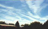
If contrails persist for a long enough period of time, say on the order of an hour or more, they can spread out across the sky due to the prevailing winds at the level at which they formed. The two figures below show how contrails generated on this particular day spread out fairly quickly due to the stronger jet stream of air aloft. Persistence of contrails is neither an indication that they contain some kind of chemical, nor that it is some kind of spray. As a matter of fact, sailors have known for some time to look specifically at the patterns and persistence of jet contrails for weather forecasting. On days where the contrails disappear quickly or don't even form, they can expect continuing good weather, while on days where they persist, a change in the weather pattern may be expected.
|
|
Contrails are a concern in climate studies as increased jet traffic may result in an increase in cloud cover. Several scientific studies are being conducted with respect to contrail formation and their climatic effects. Cirrus clouds affect Earth's climate by reflecting incoming sunlight and inhibiting heat loss from the surface of the planet. It has been estimated that in certain heavy air-traffic corridors, cloud cover has increased by as much as 20%. Since contrails can spread out and essentially become cirrus clouds, it is felt that contrails may affect the planetary climate in similar ways. Other studies are underway to better understand the role that jet exhaust itself plays in modifying the chemistry of the upper levels of the atmosphere.
How can I find out more about contrails?
There is a lot of information on the internet regarding contrails and some of the studies that are ongoing relating to research attempts at better understanding contrails. Those links provided below are only a few of the locations elsewhere on the web where you can find more information regarding contrails.
-
CIMSS
Contrail Web Page
- NASA-Study regarding contrails as seen with lidar
- NASA-The Atmospheric Effects of Aviation Project
- Atmospheric Radiation Measurement (ARM) Program
(Link no longer valid)
https://www.wrh.noaa.gov/Flagstaff/science/contrail.htm
